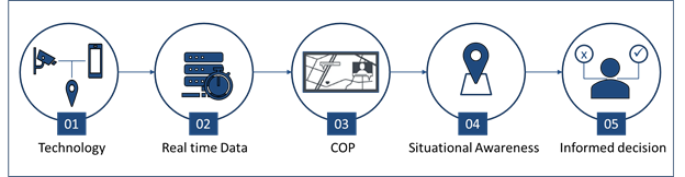
Situational Awareness is the ability to collate information from multiple sources in real- time to present actionable insights.
Constructing situational awareness requires a suite of technologies to fully exploit the assets in the field in real-time. In simple terms, this concept is called the Common Operational Picture (COP).
Industry Requirement Use Case: Public Safety
The time between alert and action, for example, between the moment a citizen dials 9-1-1 and the moment a first responder is dispatched to the scene cannot be treated as a matter of convenience. To ensure a rapid and efficient response, public safety officials need easy access to relevant information, and the ability to visualize it and to make informed decisions accordingly.
From AI-enabled cars to IoT devices, recent years have seen a flood of innovation in connectivity, resulting in massive amounts of data. In addition to the location of the caller, public safety officials can now harness additional data to increase their efficiency and quality of response. However, with increased data there is an obvious challenge of turning the information into action, for example, combing through gigabytes of raw data from Department of Transportation (DoT) cameras and turning it into actionable intelligence.
Situational awareness for public safety means having full, real-time visibility of the physical environment of the incident by connecting and integrating both human and device-generated data to form a robust COP.
Salient Technologies Impacting Public Safety
Through advanced software and hardware, COP technology brings together disparate data streams. While the sources of this data differ from one industry to the next, they are all essentially designed for the same purpose — delivering actionable intelligence in real-time to improve organizational decision-making. There are 6 key components for a robust COP:
- Location Services: Positioning technologies provide information detailing the physical whereabouts and tracking of both humans and machines.
- Maps: Tools representing a physical area of indoor or outdoor topology. These are key to provide context and additional information related to the location of interest; for example, for a fire situation, highlighting the location of fire hydrants near the incident. Maps can also be supplemented with explanatory notes and additional information.
- Machine data: Devices such as cameras or sensors that collect and transmit data to provide additional insights.
- Public data: Additional data sources can provide details such as “Person of Interest” information, social media content, or public health records to assist public safety officials to target specific needs of citizens.
- GIS Data Management: Management of spatial and non-spatial data in specific datasets to provide efficient multi-user access to such data. Typical datasets could be topologies, utility networks, and the like.
- Analytics: Process to cleanse, transform and model data both from history and real-time to perform or assist on tasks that generally require human intelligence.
Comtech's Emergency Suite
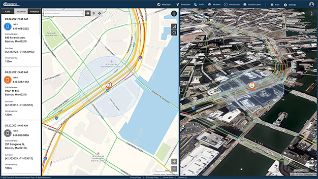
Comtech’s Emergency Suite aggregates and integrates location, camera feeds, real-time weather, traffic, data analytics, resource tracking, social media inputs, records information and more into a single, intuitive interface with layered geospatial mapping.
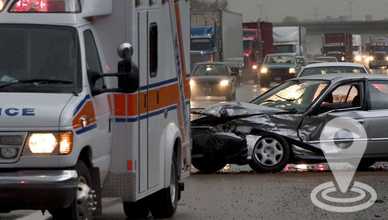
Consider the scenario of a multi-vehicle collision on a highway. A Public Safety Answering Point (PSAP) equipped with Emergency Suite will not only be able to receive the 9-1-1 call and display the caller’s location on a layered map with any suitable GIS data, but also lace a geofence around the location and access the DoT cameras obtaining the live feed. In addition to noting the number of vehicles in the collision, the PSAP will also be able to determine any extraordinary needs such as the presence of a HAZMAT vehicle, thereby providing a response customized to the situation. In addition, live traffic and weather conditions enhance the awareness of the first responders.
Emergency Suite enables access to a plethora of information from public records, social media, etc., to further enhance the experience and development of efficient, optimized public safety responses.
COPs will continue to evolve with the proliferation of newer technologies for public safety and law enforcement agencies. For such operations, decision-makers tasked with optimizing internal business processes, neutralizing threats, and safeguarding assets, must invest in a solution capable of delivering the level of situational awareness needed to make well-informed, competitive decisions.
If your organization is interested in learning more about Comtech's Emergency Suite, contact us today to schedule a demonstration of the platform.